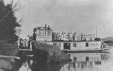
Excursion Boat to Split Rock
| “Split Rock is a formation of conglomerate rock. Located at the mouth of Woolper Creek, the site was created when the Illinoian glacier moved through the area 132,000 to 300,000 years ago and deposited the material where it is today. The split was caused by erosion from the Ohio River. It was a popular trading place since the time of Native Americans and settlers. It was also a well-known picnic and camping location.” - Liza Marie Vance |
 |
 |
|
| from the Boone County Local History Department | ||
 |
 |
 |
| Frank Snyder, photo |
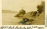
Split Rock, on the Ohio River,
near the mouth of Wolper Creek
Postmarked Lawrenceburg, Ind., 1912. to Mrs. Eugene Booth,
541 Terrace
Avenue, Clifton, Cincinnati, Ohio, My Dear Nanny - All is well. Will be up
Saturday on the train. Look for me at Pogues. Have the
tickets. Lovingly, E.C.G.
 |
 |
| This late 19th Century map refers to Split Rock as “Kirby's Rocks” | The Split Rock's Conservancy's contemporary map of the Split Rock location. |
 |
 |
|
| Split Rock, c. WWI | The spring at Split Rock, c. WWI |
Bernie and Victoria (Peggy) Schilling, at Split Rock, 1939
From a Facebook post by their daughter, Linda Schilling Mitchell
 |
 |
 |
 |
|
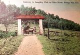
| Directly across from Split Rock was the Laughry Club - a country resort for Cincinnati elites. A short history of it is here. | ||||
![]()
A 1904 piece on Split Rock is here.
On August 19, 1906, the Courier-Journal ran a feature on Split Rock.
Shenanigans at Split Rock
![]()

