
Part 1
![]()
Virtually all of the images on this page are through the kind
cooperation of Mrs. Ann Fillmore, and were previously published in Ryle
High School PTSA's A Peek Into The Past: A History of the Union and Richwood Areas. Thanks, Ann.
![]()
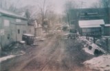
Entering Union, from Hathaway Road, circa 1910
 |
 |
An aerial view of Union, looking southwest, circa 1910
The image on the right is a key to what you're seeing in the
image on the left.
 |
 |
|
Union School, on Mt. Zion Road |
School on Hathaway Road |
 |
 |
This is a hand drawn map of Union |
Union, 1883 |
 |
 |
 |
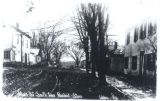
| Main Street looking south, From the hotel, that's the Presbyterian Church in the distance. |
Main Street looking south, same scene as left, a little further south |
Main Street |
 |
 |
| Union, in the early 1980's | The S & S Service Center, 1963 “The Brightest Spot on US 42” |
![]()
The City of Union is here
![]()