

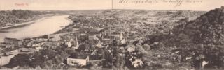
Stereoview Aerial of Maysville, c. 1880

Aerial view during the 1913 Flood
|
|
|
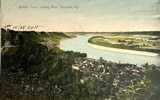
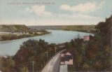
| Taken From the Devils Backbone | ||


from the Germantown Turnpike Road

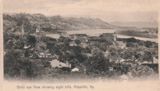
1908
 |
 |
| c.1910 | c. 1910 |
 |
 |
 |
| undated | Maysville, August, 1949 |
 |
 |
 |
| 1953 | East Maysville | “Lexington Pike” |

An aerial by noted Maysville photographer J. T. Kackley

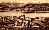
from Buffalo Trace, c. 1900
 |
 |
 |
| These are all c. 1910. Note distilleries in the far right image. | ||
 |
 |

|
| Maysville Aerial, April, 1955 |
Maysville Aerial, 1953 |
Aerial View of Maysville, unknown date |
 |
 |
 |
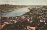
| Maysville, from Buffalo Trace, 1907 | Views from the Devil’s Backbone are relatively common. Here’s a view of the Devil's Backbone, 1911. |
from Germantown Pike |

from Aberdeen
note the shadow of the bridge
 |
 |
| Both of these are Corps of Engineers photos | |
 |
 |
 |
| Hills Back of Maysville | Maysville, c. 1920 | Aerial View of Maysville, unknown date |
 |
 |
 |
 |
| Maysville from Smoky Hollow, 1921 |
Maysville from Smoky Hollow |
Simon Kenton Bridge and river view |
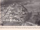
A more contemporary aerial view of Maysville |
 |
 |
 |
 |
| Eight Hills of Maysville, 1906 |
Stoney Hollow and Hill City Pike |
Maysville, c. 1977 |
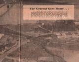
The Eisenhower Funeral Train Passes thru Maysville |

The early 1960's.
From a Facebook post by Lisa Collins

From a Facebook post by Duke Ford
 |
 |
 |
| Scene of the Grand Union Barbeque, Maysville, 1861 Read all about it, here |
Aerial View of Maysville Note construction of Tollgate on the Bridge and the Central Presbyterian Church next to it. |
Maysville, Kentucky and Aberdeen, Ohio Thanks! to Regina Stewart for the above image |
Another Great Union BBQ was in 1856. It's details are here.
 |
 |
| These are compilations of aerial photography at the National Archives. From 1950's. BIG files. | |
![]()